
Þráðlaus veðurnemi með GPS staðsetningu
PASPS3209
Lýsing
Fylgstu með veðrinu á nýjan hátt.
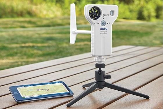
Þráðlausi veðurneminn er alhliða mælitæki notað til að fylgjast með umhverfisskilyrðum. Með því að sameina nokkra nema í eitt tæki, er neminn fær um að gefa upp 17 mismunandi mæleiningar !
Notið nemann í skráningarviðmóti eða með vindhana-aukabúnaðinum fyrir langtíma rannsóknir.
Hann nýtist einnig sem handhægt tól til að rannsaka loftslag á þröngt afmörkuðum svæðum og til að skrásetja umhverfisskilyrði margra líffræði- eða umhverfisfyrirbrigða.
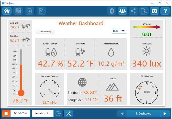
17 mismunandi mælieiningar :
Veður :
1. Umhverfishiti
2. Loftþrýstingur
3. Vindhraði
4. Vindátt
5. Rakastig
6. Reyndarrakastig
7. Daggarmörk
8. Vindkæling
9. Hitaálag
Ljós :
10. Umhverfisbirta (lux)
11. ÚF-stuðull (UV-index)
GPS :
12. Breiddargráða
13. Lengdargráða
14. Hæð yfir sjávarmáli
15. Hraði
16. Segulstefna
17. Raunstefna
Hægt er að fá aukabúnað fyrir þráðlausa veðurnemann sjá : PASPS3553
Framleiðandi : PASCO Scientific (www.pasco.com)
The Wireless Weather Sensor with GPS is an all-in-one instrument for monitoring environmental conditions. A built-in anemometer as well as sensing elements for temperature, humidity, pressure, light, and GPS the sensor provides up to 17 different measurements that can be used individually or simultaneously.
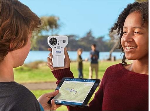
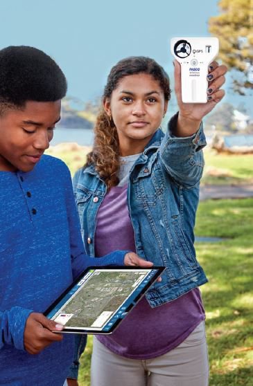
Use the sensor in logging mode with the optional Weather Vane Accessory for long-term monitoring, or use it as a hand-held instrument to study microclimates and record ambient conditions relevant to many biological and environmental phenomena.
Conduct GIS/mapping experiments using the onboard GPS sensor in conjunction with any of the other available measurements. The new map display in PASCO software provids a way for students to analyze spatial data.
Best of all, even with the versatility and functionality available, the Wireless Weather Sensor with GPS is simple and intuitive for students to use.
Note: The anemometer can only be used in winds at or below the max speed rating. Using it in hurricane level winds or with a leaf blower can damage the unit.
Typical Applications
Conduct weather sensor experiments by collecting long term weather data
Study wind and pressure changes as a storm approaches
GIS and mapping activities
Investigate microclimates
Provide spatial information for mapping other sensor data
Special Features
Logging mode for long term experiments
Water resistant for extended environmental monitoring
Built-in light sensor for measuring light level and UV index
New map display (in PASCO software) for analyzing spatial data
17 different measurements that can be collected and analyzed individually or simultaneously.
Framleiðandi : PASCO Scientific (www.pasco.com)
Þráðlausi veðurneminn er alhliða mælitæki notað til að fylgjast með umhverfisskilyrðum. Með því að sameina nokkra nema í eitt tæki, er neminn fær um að gefa upp 17 mismunandi mæleiningar !
Notið nemann í skráningarviðmóti eða með vindhana-aukabúnaðinum fyrir langtíma rannsóknir.
Hann nýtist einnig sem handhægt tól til að rannsaka loftslag á þröngt afmörkuðum svæðum og til að skrásetja umhverfisskilyrði margra líffræði- eða umhverfisfyrirbrigða.
17 mismunandi mælieiningar :
Veður :
1. Umhverfishiti
2. Loftþrýstingur
3. Vindhraði
4. Vindátt
5. Rakastig
6. Reyndarrakastig
7. Daggarmörk
8. Vindkæling
9. Hitaálag
Ljós :
10. Umhverfisbirta (lux)
11. ÚF-stuðull (UV-index)
GPS :
12. Breiddargráða
13. Lengdargráða
14. Hæð yfir sjávarmáli
15. Hraði
16. Segulstefna
17. Raunstefna
Hægt er að fá aukabúnað fyrir þráðlausa veðurnemann sjá : PASPS3553
Framleiðandi : PASCO Scientific (www.pasco.com)
The Wireless Weather Sensor with GPS is an all-in-one instrument for monitoring environmental conditions. A built-in anemometer as well as sensing elements for temperature, humidity, pressure, light, and GPS the sensor provides up to 17 different measurements that can be used individually or simultaneously.
Use the sensor in logging mode with the optional Weather Vane Accessory for long-term monitoring, or use it as a hand-held instrument to study microclimates and record ambient conditions relevant to many biological and environmental phenomena.
Conduct GIS/mapping experiments using the onboard GPS sensor in conjunction with any of the other available measurements. The new map display in PASCO software provids a way for students to analyze spatial data.
Best of all, even with the versatility and functionality available, the Wireless Weather Sensor with GPS is simple and intuitive for students to use.
Note: The anemometer can only be used in winds at or below the max speed rating. Using it in hurricane level winds or with a leaf blower can damage the unit.
Typical Applications
Conduct weather sensor experiments by collecting long term weather data
Study wind and pressure changes as a storm approaches
GIS and mapping activities
Investigate microclimates
Provide spatial information for mapping other sensor data
Special Features
Logging mode for long term experiments
Water resistant for extended environmental monitoring
Built-in light sensor for measuring light level and UV index
New map display (in PASCO software) for analyzing spatial data
17 different measurements that can be collected and analyzed individually or simultaneously.
Framleiðandi : PASCO Scientific (www.pasco.com)